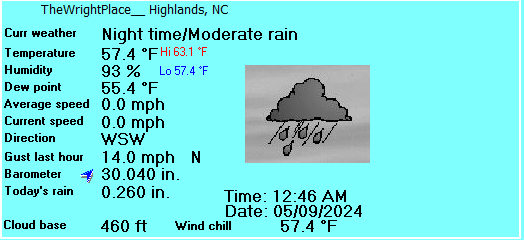
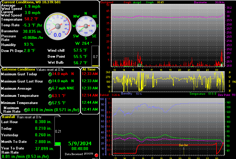
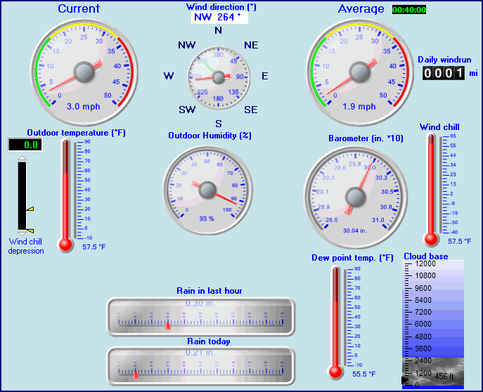
| TheWrightPlace | |||
|---|---|---|---|
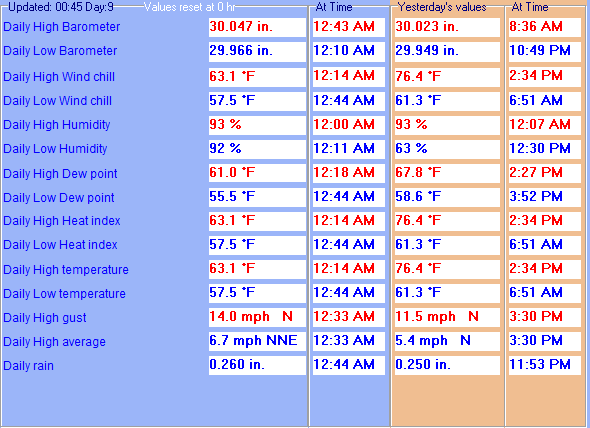
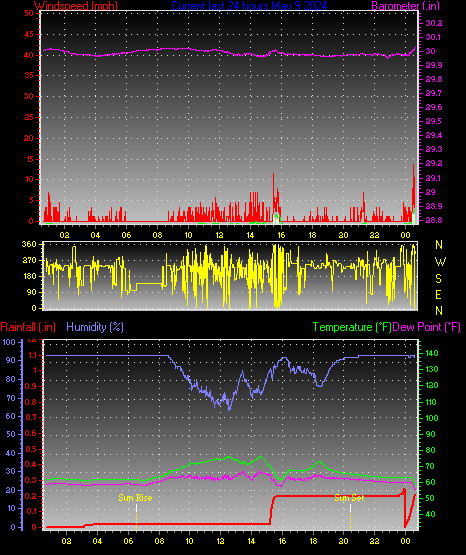
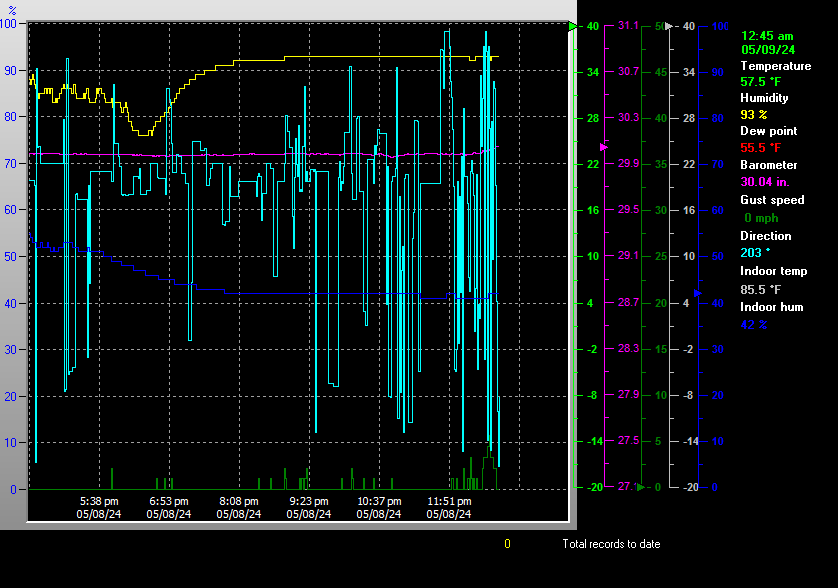
| LAST READING AT TIME: 12:45 AM DATE: May 09 2024, time of next update: 12:50 am | |||
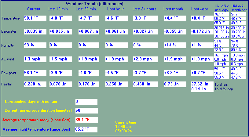
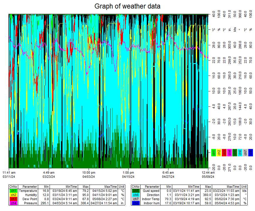
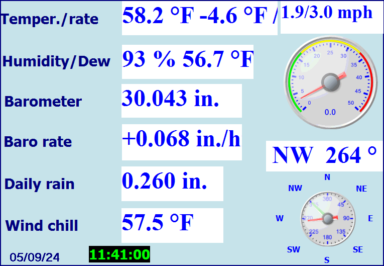
| Current Weather | Night time/Moderate rain | Current Temperature | 57.5°F (14.2°C), Apparent temp 59.1°F |
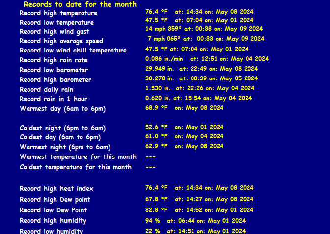
| Maximum Temperature (since midnight) | 63.1°F at: 12:14 AM | Minimum Temperature (since midnight) | 57.5°F at: 12:44 AM |
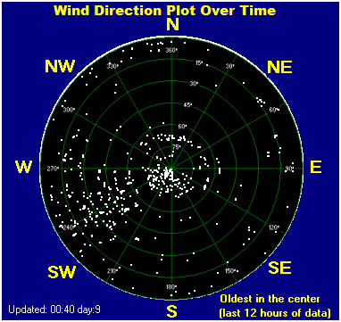
| Average windspeed (ten minute) | 1.3 mph | Wind Direction (ten minute) | NW (323°) |
| Windchill Temperature | 57.5°F | Maximum Gust (last hour) | 14 mph at: 12:33 AM |
| Maximum Gust (since midnight) | 14 mph at: 12:33 AM | Maximum 1 minute average (since midnight) | 6.7 mph at: 12:33 AM |
| Rainfall (last hour) | 0.300 in. (7.6 mm) | Rainfall (since midnight) | 0.260 in. (6.6 mm) at 12:44 AM |
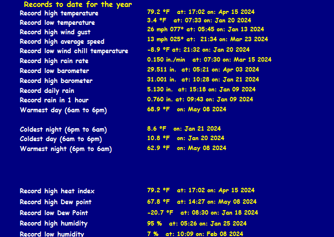
| Rainfall This month | 2.80 in. (71.1 mm) | Rainfall To date this year | 37.099 in. (942.3 mm) |
| Maximum rain per minute (last hour) | 0.010 in/min | Maximum rain per hour (last 6 hours) | 0.300 in/hour |
| Yesterdays rainfall | 0.260 in | DewPoint | 55.5°F (Wet Bulb :56.4°F ) |
| Humidity | 93 %, Humidex 62.6°F | Barometer corrected to msl | 30.043 in. (1017.4 hPa) |
| Pressure change | +0.07 in. (last hour) | Trend (last hour) | RISING SLOWLY |
| Pressure change (last 12 hours) | +0.06 in | Pressure change (last 6 hours) | +0.08 in |

Expires:202405090800;;881937
FPUS52 KGSP 090329 AAA
ZFPGSP

Zone Forecast Product
National Weather Service Greenville-Spartanburg SC
1129 PM EDT Wed May 8 2024


NCZ062-090800-
Macon-
Including the cities of Franklin, Rainbow Springs, Kyle,
and Highlands
1129 PM EDT Wed May 8 2024

...TORNADO WATCH 214 IN EFFECT UNTIL 4 AM EDT THURSDAY...

.REST OF TONIGHT...Showers and thunderstorms. Patchy fog. Some
thunderstorms may be severe with damaging winds and large hail.
Locally heavy rainfall possible. Lows around 60. Southwest winds
5 to 10 mph with gusts up to 25 mph. Chance of rain near
100 percent.
.THURSDAY...Patchy fog in the morning. Cloudy with showers and
thunderstorms in the morning, then partly sunny with a chance of
showers and thunderstorms in the afternoon. Highs in the mid 70s.
West winds 10 to 15 mph with gusts up to 30 mph. Chance of rain
90 percent.
.THURSDAY NIGHT...Partly cloudy. Lows in the mid 50s. West winds
10 to 15 mph.
.FRIDAY...Mostly sunny in the morning, then becoming partly sunny. A
chance of showers. Breezy with highs in the upper 60s. Northwest
winds 15 to 20 mph with gusts up to 30 mph. Chance of rain
40 percent.
.FRIDAY NIGHT...Mostly clear. A chance of showers in the evening.
Breezy with lows in the lower 40s. Northwest winds 15 to 20 mph with
gusts up to 30 mph. Chance of rain 30 percent.
.SATURDAY...Sunny, breezy with highs in the mid 60s.
.SATURDAY NIGHT...Mostly clear and breezy. Lows in the mid 40s.
.SUNDAY...Sunny. Highs in the upper 60s.
.SUNDAY NIGHT...Mostly clear. Lows in the upper 40s.
.MONDAY...Mostly sunny in the morning, then becoming partly sunny.
Highs in the upper 60s.
.MONDAY NIGHT...Mostly cloudy. A chance of showers after midnight.
Lows in the lower 50s. Chance of rain 40 percent.
.TUESDAY...Mostly cloudy. A chance of showers in the morning, then
showers likely with a chance of thunderstorms in the afternoon.
Highs in the upper 60s. Chance of rain 70 percent.
.TUESDAY NIGHT...Showers likely with a chance of thunderstorms. Lows
in the mid 50s. Chance of rain 70 percent.
.WEDNESDAY...Showers likely. A chance of thunderstorms in the
afternoon. Highs in the lower 70s. Chance of rain 70 percent.

$$